Tuesday, May 16, 2006

The Brothers/S. Coulior


Date: 5/15 - 5/16/2006
Route: South Coulior Difficulty: Basic Alpine.
Climbers: Jim Ferris, Chris Kirsten, Bari Bookout, Frank Jessep, Andrew Zuanic, Ann Oleary.

On Friday I met Ann and Frank at the 65th Ravenna Park and Ride to head to the Bremerton via the Ferry to climb The Brothers in Olympic National Park. The plan was to Meet Jim at the Lena Lake trailhead. We ate breakfast in Bremerton and then arrived at the trailhead at 12pm by which time it had gotten fairly hot. We began at 900ft up VERY gradual gain, and VERY long switchbacks. We then entered the "Valley of Silent Men" which is one of the coolest, densley populated forrest valleys I've been in. The trail follows the creek through the valley eventually reaching snow. Large waterfalls poured down onto swimming holes, which ran through mossy streambeds.


A number of great hand-crafted wood bridges crossed and re-crossed the active stream.
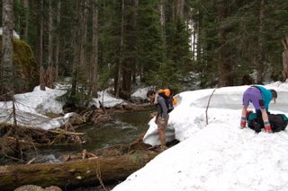


We eventually reached the snowline and the trailhead dissappeared. This caused us to encounter some minor routefinding issues. Kirk Alm had done the Brothers two days before us, so we tried to follow his tracks in the snow. However, we ended up not taking the correct fork at Lena Camp and heading too far to the east. There were countless numbers of treewells and snowbridges that were suspect and every so often we would plunge right through. After we all looked briefly at the topo map, we agreed found the correct heading. We arrived at camp in the early evening.


What the hell do you want, don't you see I"m trying to get some sleep? ; - )


The following morning we began heading up the snowfield. Our route took us from up a couple of narrow gullies, and over a moat. The moat proved to be the true crux of the climb as much of the snow had melted out and went into a dark hole just big enough to swallow someone. There was also a man eating plant that had long branches that attempted to block our way. We prevailed.


Finally enjoying a hard days work on the summit of the Brothers.


On the summit, Ann rests momentarily enjoying views on exposed summit ridgeline before she makes her way to the summit.
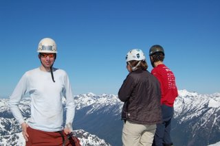


Summit with Olympic Range in the background.

We desended back down to camp and reached the cars at approximately 2:30pm. It was a great trip with great weather and cool people.


Thursday, May 04, 2006

Mt Hood/Leuthold Col

Route: Leuthold Col
Difficulty: Grade II Ice
Elevation Gain: 5,200ft.


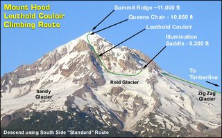
On April 28th, 2006 Jiri Richter, Atzuko, Martin Babare and myself set out to climb Mt Hood via the Leuthold Col. The climb is rated a Grade II Ice climb and is a great climb when the conditions are just right, otherwise it is a rockfall/avalanche funnel.

The four of us started out carpooling from the Tacoma Park&Ride and heading south to Oregon. We made quick stop for dinner along the way in Zig Zag. Pizza and Beer were on the menu. We arrived at the Timerbline Government Camp at approximately 7:45pm. (6000ft). The temperature was around 47 degrees. The night was clear and we definitely had the weather on our side. Martin and I carcamped in my Subaru while the others slept nearby. We woke up at 12:05am to get our packs ready.


We began our slog up the mountain. It was a clear night, and my pack still seemed heavy even though I had gutted it twice before leaving the parking lot. Jiri was on skies and was in the best shape out of anyone in the group. We continued the slog up in the fairly soft and slushy snow up the Palmer Snowfield and past the Ski lifts. Once past the lifts, we turned left to head over to Illumination Saddle. When we arrived at the saddle, we noticed a tent and a dude just waking up by himself and getting ready to climb. He indicated that he was also destined for the Leuthold, but he "had to do it quick, because he had to go to work today". We found this pretty amazing, let alone doing the Leuthold solo. Since he had done this route before, we decided to follow his lead.

We descended onto the Reid Glacier. This was a very steep downclimb, in which we faced the mountain and self belaying until we reached the glacier. We decided that based on the heavy amount of Snow and few crevasses that we would travel unroped. As we traversed the Reid, we crossed several avalanche debris fields that looked fairly new. One of the key routefinding challenges for this climb is to identify the correct Coulier. (The base of the Leuthold Col is on the far left). We arrived at the base and made another decision to not place pickets. Everyone was fairly comfortable with this decision and we began the climb up the steep snow. The gain from the base of the Col to where it opens up at the summit ridge is approximately 2,000ft.


Initially it was simply very steep snow when we entered the Col. After about 800ft, in the middle of the hourglass the snow became very hard with a hard crust. While this made for solid cramponing, we were unable to continue to self belay. We took our second ice tools out turned to dagger position as we leaned into the mountain. For some strange reason, there were the occasional golf ball size chunks of ice that would come tumbling down the Coulier. As we approached the base of the Coulier, the orange tint in the Horizon could be seen as the sun began to rise.


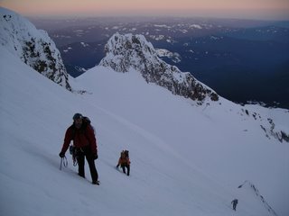
Atsuko heading up the Leuthold.
The gully makes a couple of twists and turns before finally opening up.


Here is Chris following not far behind in dagger Position unprotected climbing up the Coulier.


Chris topping out at the ridgeline for a break and sees plenty of relief on the other side.